| All Projects |
Current Project
| LABRADOR SHELF: 8624-D003-002E | |
|---|---|
| Company: | DOME PETROLEUM |
| Contractor: | GSI |
| Min Max Latitude: |
55.45 55.87 |
| Min Max Longitude: |
-57.9 -56.7 |
| Year: | 1982 |
| Descriptions: | ADLAVIK AREA |
For more information on this project, please contact:
Exploration Department, Canada-Newfoundland and Labrador Offshore Petroleum Board
240 Waterford Bridge Road, The Tower Corporate Campus - West Campus Hall,
Suite 7100, St. John's, Newfoundland and Labrador, A1E 1E2
Phone: (709) 778-1400
Fax: (709) 778-1473
E-Mail: information@cnlopb.ca
Contact:
Title:
Website: http://www.cnlopb.ca
Map and Table Data
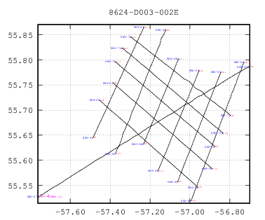
number of wells on plot: 2
Download this plot in Postscript format. Click the plot for a large JPEG version.
12 records Returned
(All Coordinates | Data Accuracy)Export to Excel | Print Version (Wide Table Format)
| Line | Line Distance (kms) | Start Shotpoint | Lat of Start | Lon of Start | End Shotpoint | Lat of End | Lon of End |
|---|---|---|---|---|---|---|---|
| EBK-61 | 29.27 | 101 | 55.65 | -57.49 | 1267 | 55.87 | -57.23 |
| EBK-62 | 31.69 | 101 | 55.86 | -57.12 | 1373 | 55.61 | -57.37 |
| EBK-63A | 21.87 | 101 | 55.63 | -57.23 | 975 | 55.8 | -57.06 |
| EBK-64 | 25.78 | 101 | 55.78 | -56.95 | 1133 | 55.58 | -57.16 |
| EBK-65 | 27.81 | 101 | 55.56 | -57.06 | 1214 | 55.78 | -56.85 |
| EBK-66 | 34.94 | 101 | 55.8 | -56.73 | 1500 | 55.52 | -56.99 |
| EBK-67A | 72.28 | 406 | 55.53 | -57.76 | 3291 | 55.79 | -56.7 |
| EBK-68 | 36.57 | 101 | 55.55 | -56.96 | 1561 | 55.72 | -57.45 |
| EBK-69 | 36.62 | 101 | 55.75 | -57.39 | 1562 | 55.58 | -56.89 |
| EBK-70 | 36.63 | 101 | 55.63 | -56.87 | 1563 | 55.8 | -57.37 |
| EBK-71A | 36.82 | 1560 | 55.65 | -56.83 | 3042 | 55.82 | -57.34 |
| EBK-72 | 35.92 | 101 | 55.69 | -56.8 | 1543 | 55.85 | -57.3 |
