| All Projects |
Current Project
| GRAND BANKS: 8624-P028-047E | |
|---|---|
| Company: | PETRO-CANADA |
| Contractor: | SEFEL |
| Min Max Latitude: |
46.12 46.57 |
| Min Max Longitude: |
-48.94 -48.39 |
| Year: | 1982 |
| Descriptions: | SOUTH HIBERNIA BLOCK |
For more information on this project, please contact:
Exploration Department, Canada-Newfoundland and Labrador Offshore Petroleum Board
240 Waterford Bridge Road, The Tower Corporate Campus - West Campus Hall,
Suite 7100, St. John's, Newfoundland and Labrador, A1E 1E2
Phone: (709) 778-1400
Fax: (709) 778-1473
E-Mail: information@cnlopb.ca
Contact:
Title:
Website: http://www.cnlopb.ca
Map and Table Data
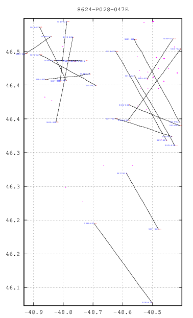
number of wells on plot: 121
Download this plot in Postscript format. Click the plot for a large JPEG version.
17 records Returned
(All Coordinates | Data Accuracy)Export to Excel | Print Version (Wide Table Format)
| Line | Line Distance (kms) | Start Shotpoint | Lat of Start | Lon of Start | End Shotpoint | Lat of End | Lon of End |
|---|---|---|---|---|---|---|---|
| 5034-82I | 14.91 | 1 | 46.37 | -48.43 | 597 | 46.4 | -48.62 |
| 5035-82I | 19.83 | 1 | 46.13 | -48.5 | 794 | 46.24 | -48.7 |
| 5036-82I | 13.52 | 1 | 46.42 | -48.58 | 540 | 46.39 | -48.41 |
| 5037-82I | 12.35 | 1 | 46.32 | -48.59 | 497 | 46.24 | -48.48 |
| 5038-82I | 17.97 | 1 | 46.5 | -48.41 | 721 | 46.4 | -48.58 |
| 5039-82I | 19.65 | 1 | 46.37 | -48.45 | 788 | 46.5 | -48.62 |
| 5040-82I | 9.31 | 1 | 46.46 | -48.52 | 373 | 46.52 | -48.43 |
| 5041-82I | 15.44 | 1 | 46.46 | -48.56 | 616 | 46.36 | -48.42 |
| 5042-82I | 15.35 | 1 | 46.45 | -48.69 | 620 | 46.5 | -48.88 |
| 5043-82I | 17.99 | 1 | 46.4 | -48.41 | 723 | 46.52 | -48.56 |
| 5044-82I | 11.54 | 1 | 46.47 | -48.71 | 464 | 46.46 | -48.86 |
| 5045-82I | 14.62 | 1 | 46.52 | -48.77 | 586 | 46.4 | -48.82 |
| 5046-82I | 4.97 | 1 | 46.49 | -48.83 | 200 | 46.49 | -48.77 |
| 5046-82IA | 4.39 | 1141 | 46.49 | -48.79 | 1316 | 46.49 | -48.73 |
| 5047-82I | 9.92 | 1 | 46.46 | -48.81 | 399 | 46.54 | -48.79 |
| 5048-82I | 7.19 | 1 | 46.52 | -48.84 | 289 | 46.5 | -48.93 |
| 5049-82I | 11.12 | 1 | 46.46 | -48.79 | 451 | 46.54 | -48.88 |
